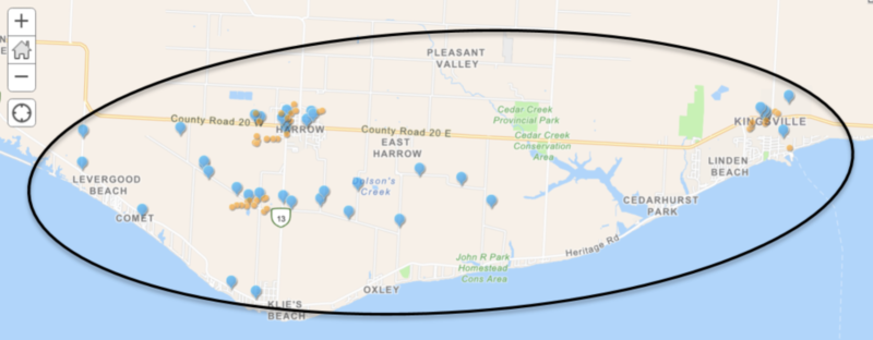
Last week, a team from Western University’s Northern Tornadoes Project (NTP) visited Essex County to assess the damage to homes, trees and other structures caused by the July 26 storm that ripped through parts of the county.
NTP uses satellite data, surveillance planes, drones and on-the-ground observation to analyze tornado events and the damage they leave behind. They have confirmed that an EF1 tornado and downburst was the cause of extensive damage to homes, trees, sheds and crop fields with Kingsville, Harrow and Blenheim bearing the brunt of the storm.
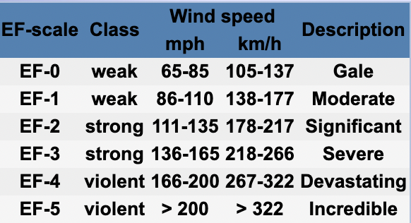
Classed as a weak weather event with moderate damage, EF1 tornadoes display wind speeds of 138 – 177 km/hr.

Starting at 3:55 pm on July 26, the storm hit Harrow-Colchester first damaging power poles and trees before moving eastward to Kingsville where trees were brought down and damage to houses and buildings resulted.
The NTP review conducted on July 27 also observed damage to barns and crops. No injuries were reported. The Kingsville-Harrow storm has been classified as an EF1 downburst with estimated maximum wind speeds of 145 km/hr.

The storm hit Blenheim at 4:35 pm. No injuries were reported however there was damage to homes, sheds, trees and crops. NTP conducted a ground and drone survey on July 27 and documented a long 9.77 km track of damage with a narrow path width of 300 m.
The Blenheim storm has been classified as an EF1 tornado with estimated maximum wind speeds of 160 km/hr.

EF1 is on the low end of the Enhanced Fujita (EF) scale. The scale is a method of rating tornadoes based on the estimated wind speeds and the resulting damage.
Click here to read more about the Northern Tornadoes Project